railroad.wikisort.org - Station
The Parkchester station is an express station on the IRT Pelham Line of the New York City Subway. It is located above Hugh J. Grant Circle in the Parkchester neighborhood of the Bronx, where East 177th Street (the Cross Bronx Expressway service road), Metropolitan Avenue, and Westchester Avenue intersect. The station is served by the 6 train at all times and the <6> train during weekdays in the peak direction.
Parkchester | |||||||||||||||||||||||||||||||||||||||||||||||||||||||||||||||||||||||||||||||||||||||||||||||||||||||||||||||||||||
|---|---|---|---|---|---|---|---|---|---|---|---|---|---|---|---|---|---|---|---|---|---|---|---|---|---|---|---|---|---|---|---|---|---|---|---|---|---|---|---|---|---|---|---|---|---|---|---|---|---|---|---|---|---|---|---|---|---|---|---|---|---|---|---|---|---|---|---|---|---|---|---|---|---|---|---|---|---|---|---|---|---|---|---|---|---|---|---|---|---|---|---|---|---|---|---|---|---|---|---|---|---|---|---|---|---|---|---|---|---|---|---|---|---|---|---|---|---|
 Platform level | |||||||||||||||||||||||||||||||||||||||||||||||||||||||||||||||||||||||||||||||||||||||||||||||||||||||||||||||||||||
| Station statistics | |||||||||||||||||||||||||||||||||||||||||||||||||||||||||||||||||||||||||||||||||||||||||||||||||||||||||||||||||||||
| Address | Hugh J. Grant Circle Bronx, NY 10472 | ||||||||||||||||||||||||||||||||||||||||||||||||||||||||||||||||||||||||||||||||||||||||||||||||||||||||||||||||||||
| Borough | The Bronx | ||||||||||||||||||||||||||||||||||||||||||||||||||||||||||||||||||||||||||||||||||||||||||||||||||||||||||||||||||||
| Locale | Parkchester, Unionport | ||||||||||||||||||||||||||||||||||||||||||||||||||||||||||||||||||||||||||||||||||||||||||||||||||||||||||||||||||||
| Coordinates | 40°50′0″N 73°51′39.5″W | ||||||||||||||||||||||||||||||||||||||||||||||||||||||||||||||||||||||||||||||||||||||||||||||||||||||||||||||||||||
| Division | A (IRT)[1] | ||||||||||||||||||||||||||||||||||||||||||||||||||||||||||||||||||||||||||||||||||||||||||||||||||||||||||||||||||||
| Line | IRT Pelham Line | ||||||||||||||||||||||||||||||||||||||||||||||||||||||||||||||||||||||||||||||||||||||||||||||||||||||||||||||||||||
| Services | 6 | ||||||||||||||||||||||||||||||||||||||||||||||||||||||||||||||||||||||||||||||||||||||||||||||||||||||||||||||||||||
| Transit | |||||||||||||||||||||||||||||||||||||||||||||||||||||||||||||||||||||||||||||||||||||||||||||||||||||||||||||||||||||
| Structure | Elevated | ||||||||||||||||||||||||||||||||||||||||||||||||||||||||||||||||||||||||||||||||||||||||||||||||||||||||||||||||||||
| Platforms | 2 island platforms cross-platform interchange | ||||||||||||||||||||||||||||||||||||||||||||||||||||||||||||||||||||||||||||||||||||||||||||||||||||||||||||||||||||
| Tracks | 3 | ||||||||||||||||||||||||||||||||||||||||||||||||||||||||||||||||||||||||||||||||||||||||||||||||||||||||||||||||||||
| Other information | |||||||||||||||||||||||||||||||||||||||||||||||||||||||||||||||||||||||||||||||||||||||||||||||||||||||||||||||||||||
| Opened | May 30, 1920[3] | ||||||||||||||||||||||||||||||||||||||||||||||||||||||||||||||||||||||||||||||||||||||||||||||||||||||||||||||||||||
| Accessible | not ADA-accessible; accessibility planned | ||||||||||||||||||||||||||||||||||||||||||||||||||||||||||||||||||||||||||||||||||||||||||||||||||||||||||||||||||||
| Opposite- direction transfer | Yes | ||||||||||||||||||||||||||||||||||||||||||||||||||||||||||||||||||||||||||||||||||||||||||||||||||||||||||||||||||||
| Former/other names | Parkchester–East 177th Street East 177th Street–Parkchester East 177th Street | ||||||||||||||||||||||||||||||||||||||||||||||||||||||||||||||||||||||||||||||||||||||||||||||||||||||||||||||||||||
| Traffic | |||||||||||||||||||||||||||||||||||||||||||||||||||||||||||||||||||||||||||||||||||||||||||||||||||||||||||||||||||||
| 2019 | 4,734,709[4] | ||||||||||||||||||||||||||||||||||||||||||||||||||||||||||||||||||||||||||||||||||||||||||||||||||||||||||||||||||||
| Rank | 97 out of 424[4] | ||||||||||||||||||||||||||||||||||||||||||||||||||||||||||||||||||||||||||||||||||||||||||||||||||||||||||||||||||||
| |||||||||||||||||||||||||||||||||||||||||||||||||||||||||||||||||||||||||||||||||||||||||||||||||||||||||||||||||||||
| |||||||||||||||||||||||||||||||||||||||||||||||||||||||||||||||||||||||||||||||||||||||||||||||||||||||||||||||||||||
| |||||||||||||||||||||||||||||||||||||||||||||||||||||||||||||||||||||||||||||||||||||||||||||||||||||||||||||||||||||
| |||||||||||||||||||||||||||||||||||||||||||||||||||||||||||||||||||||||||||||||||||||||||||||||||||||||||||||||||||||
| |||||||||||||||||||||||||||||||||||||||||||||||||||||||||||||||||||||||||||||||||||||||||||||||||||||||||||||||||||||
| |||||||||||||||||||||||||||||||||||||||||||||||||||||||||||||||||||||||||||||||||||||||||||||||||||||||||||||||||||||


By passenger count, Parkchester was the third-busiest station in the Bronx in 2017, behind 161st Street–Yankee Stadium and Third Avenue–149th Street, and the busiest station on the Pelham Line.
History
Parkchester station opened on May 30, 1920.[3]
This station was rehabilitated in 2010.
In 2019, the Metropolitan Transportation Authority announced that this station would become ADA-accessible as part of the agency's 2020–2024 Capital Program.[5]
Station layout
| P Platform level |
Southbound local | ← |
| Island platform | ||
| Peak-direction express | ← (No service: Pelham Bay Park) → | |
| Island platform | ||
| Northbound local | | |
| M | Mezzanine | Station agent, MetroCard vending machines, fare control |
| G | Street level | Exit/entrance |
Parkchester is an express station with three tracks and two island platforms. The 6 stops on the outer local tracks while the <6> stops on the center express track. There are 1950s-style mushroom-shaped lights at the end of the platforms and the staircases to the mezzanine are sheltered. Just north of the station is a signal tower which was used until the late 1990s, when a new master tower was created in Westchester Yard.
When <6> express trains operate, 6 local trains terminate here. After discharging passengers on the northbound local track, terminating trains use the center track past switches north of the station as a pocket track to relay.
All trains continuing on the IRT Pelham Line north of this station make all subsequent stops, these stations are only served by the <6> in the peak direction when it is operating, and the 6 at all other times.
Exit
The station's only exit is a mezzanine in the center of the Hugh Grant Circle, a traffic circle. It has a crossunder and windows in a simulated 12-pane pattern similar to those at Whitlock Avenue. The fare control is at street level and the room features a painting entitled Live The Dream. There is an escalator from fare control to the southbound platform, bypassing the mezzanine.[6]
Image gallery
 Entrance to Parkchester station
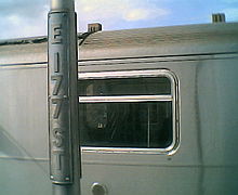 The lampposts at the station, which still read "E 177 ST"
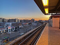 Facing a sunset on the Northbound local track.
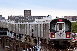 An R142A 6 local train approaching Parkchester


References
- "Glossary". Second Avenue Subway Supplemental Draft Environmental Impact Statement (SDEIS) (PDF). Vol. 1. Metropolitan Transportation Authority. March 4, 2003. pp. 1–2. Archived from the original (PDF) on February 26, 2021. Retrieved January 1, 2021.
- "Bronx Bus Map" (PDF). Metropolitan Transportation Authority. October 2018. Retrieved December 1, 2020.
- "Bronx Subway Extension Opened" (PDF). New York Times. May 28, 1920. Retrieved January 25, 2016.
- "Facts and Figures: Annual Subway Ridership 2014–2019". Metropolitan Transportation Authority. 2020. Retrieved May 26, 2020.
- "Press Release - MTA Headquarters - MTA Announces 20 Additional Subway Stations to Receive Accessibility Improvements Under Proposed 2020-2024 Capital Plan". MTA. December 19, 2019. Retrieved December 25, 2019.
- "MTA Neighborhood Maps: Bronx Zoo" (PDF). mta.info. Metropolitan Transportation Authority. 2015. Retrieved July 20, 2016.
External links
- nycsubway.org – IRT Pelham Line: East 177th Street/Parkchester
- nycsubway.org — Live the Dream Artwork (Artist and date unknown)
- Station Reporter — 6 Train
- Map of Bronx Subways
- The Subway Nut — Parkchester – East 177th Street Pictures
- Hugh Grant Circle (west) entrance from Google Maps Street View
- Hugh Grant Circle (east) entrance from Google Maps Street View
- Platforms from Google Maps Street View
Stations of the New York City Subway, by service | |
|---|---|
| |
Express |
|
| |
Stations of the New York City Subway, by line (physical trackage) | |
|---|---|
| Pelham Line |
|
| |
| Authority control |
|
|---|
Другой контент может иметь иную лицензию. Перед использованием материалов сайта WikiSort.org внимательно изучите правила лицензирования конкретных элементов наполнения сайта.
WikiSort.org - проект по пересортировке и дополнению контента Википедии