railroad.wikisort.org - Station
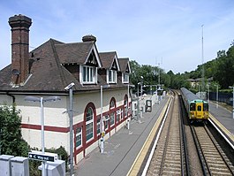
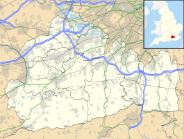
Chipstead railway station serves the village of Chipstead in Surrey. It is a late-Victorian station on the Tattenham Corner Line and was opened in 1897. The station and all trains serving it are operated by Southern. It is in Travelcard Zone 6, 18 miles 41 chains (29.8 km) from Charing Cross.
| Chipstead | |
|---|---|
 | |
 Chipstead Location of Chipstead in Surrey | |
| Location | Chipstead |
| Local authority | Borough of Reigate and Banstead |
| Managed by | Southern |
| Station code | CHP |
| DfT category | E |
| Number of platforms | 2 |
| Fare zone | 6 |
| National Rail annual entry and exit | |
| 2016–17 | |
| 2017–18 | |
| 2018–19 | |
| 2019–20 | |
| 2020–21 | |
| Railway companies | |
| Original company | Chipstead Valley Railway |
| Pre-grouping | South Eastern and Chatham Railway |
| Post-grouping | Southern Railway |
| Key dates | |
| 2 November 1897[2][3] | Opened |
| Other information | |
| External links | |
| WGS84 | 51.309°N 0.169°W |
The station buildings are no longer used by Southern, having been sold off and converted for private use in the mid-late 1990s, and a small ticket office is in a pre-fabricated building on the Up platform.
Services
All services at Chipstead are operated by Southern using Class 377 EMUs.
The typical off-peak service in trains per hour is:[4]
- 2 tph to London Bridge (non-stop from Norwood Junction)
- 2 tph to Tattenham Corner
On Sundays, the service is reduced to hourly and runs between Tattenham Corner and Purley only. Passengers for London Bridge have to change at Purley.
| Preceding station | Following station | |||
|---|---|---|---|---|
| Southern Tattenham Corner Line | ||||
References
- "Estimates of station usage". Rail statistics. Office of Rail Regulation. Please note: Some methodology may vary year on year.
- Chronology of London Railways by H.V.Borley page 50
- Southern Region Record by R.H.Clark page 69
- Table 181 National Rail timetable, May 2022
External links
- Train times and station information for Chipstead railway station from National Rail
Другой контент может иметь иную лицензию. Перед использованием материалов сайта WikiSort.org внимательно изучите правила лицензирования конкретных элементов наполнения сайта.
WikiSort.org - проект по пересортировке и дополнению контента Википедии
