railroad.wikisort.org - Station
Renall Street railway station is an urban single-platform railway station on Renall Street in the Wairarapa town of Masterton in New Zealand’s North Island. Renall Street is one of three railway stations in Masterton, the others being Masterton and Solway.
Renall Street | |||||||||||
|---|---|---|---|---|---|---|---|---|---|---|---|
| Metlink regional rail | |||||||||||
 Renall Street railway station | |||||||||||
| General information | |||||||||||
| Location | Renall Street, Masterton, New Zealand | ||||||||||
| Coordinates | 40°56.856′S 175°38.322′E | ||||||||||
| Owned by | Greater Wellington Regional Council | ||||||||||
| Line(s) | Wairarapa Line | ||||||||||
| Distance | 89.4 kilometres (55.6 mi) from Wellington | ||||||||||
| Platforms | Single side | ||||||||||
| Tracks | Main line (1) | ||||||||||
| Train operators | Transdev Wellington | ||||||||||
| Bus routes | 1 | ||||||||||
| Bus operators | Tranzit Coachlines | ||||||||||
| Connections | 201 Masterton West | ||||||||||
| Construction | |||||||||||
| Structure type | At-grade | ||||||||||
| Parking | No | ||||||||||
| Bicycle facilities | No | ||||||||||
| Other information | |||||||||||
| Station code | RENA | ||||||||||
| Fare zone | 14[1] | ||||||||||
| History | |||||||||||
| Opened | October 1936 | ||||||||||
| Closed | 25 June 1978 (freight) | ||||||||||
| Rebuilt | 2007 | ||||||||||
| Previous names | Upper Plains crossing | ||||||||||
| Services | |||||||||||
| |||||||||||
As part of the Wairarapa station upgrade programme to prepare stations for the new SW-class passenger carriages, this station was closed from 14 May 2007 until early July 2007.[2][3]
History
As the construction of the Wairarapa Line progressed in 1880, the rails reached the "Upper Plains crossing" in late August 1880. On 28 August a special train conveyed members of parliament and their families from Wellington to the "Upper Plains crossing" where some picnicked, while others were taken by coach into town to refresh themselves at a hotel.
In 1936, Renall Street became a stopping place for railcars, coinciding with the introduction of the Wairarapa railcars. Despite strong public support, it was not until 1937 that a shelter and platform were provided at the Upper Plains crossing. The station also had several private sidings serving oil companies and other industrial interests. These sidings have been removed.
Connecting Services
A nearby bus stop allows passengers to connect with bus Route 201 (Masterton West) to the town centre.
Gallery
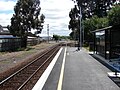 Looking north-east in the direction of Masterton from Renall Street station.
 Station just before 2007 re-build
 Station and platform looking north-east at the Renall Street level crossing and in the direction of Masterton, before rebuild


References
- Cameron, Walter Norman (1976). A Line Of Railway: The Railway Conquest of the Rimutakas. Wellington: New Zealand Railway and Locomotive Society. ISBN 0-908573-00-6.
Footnotes
- Metlink. "Text description of fare zone boundaries". Greater Wellington Regional Council. Archived from the original on 18 December 2007. Retrieved 2007-11-27.
- Radley, Matt (14 May 2007). "New Metlink Wairarapa train and Wairarapa station improvements". Greater Wellington Regional Council. Archived from the original on 27 September 2007. Retrieved 2007-10-29.
- Radley, Matt (14 June 2007). "More new carriages introduced on Wairarapa line". Greater Wellington. Archived from the original on 27 September 2007. Retrieved 2007-10-29.
External links
- Passenger service timetables from Metlink and Tranz Metro.
Другой контент может иметь иную лицензию. Перед использованием материалов сайта WikiSort.org внимательно изучите правила лицензирования конкретных элементов наполнения сайта.
WikiSort.org - проект по пересортировке и дополнению контента Википедии