railroad.wikisort.org - Station
Aubervilliers–Pantin–Quatre Chemins (French pronunciation: [obɛʁvilje pɑ̃tɛ̃ katʁ(ə) ʃəmɛ̃]) is a station of the Paris Métro. It is at the crossroads of the Roman road that led from Lutetia to east Flanders (now the N2) and the road between the communes of Aubervilliers and Pantin.
This article includes a list of general references, but it lacks sufficient corresponding inline citations. (January 2021) |
Aubervilliers–Pantin–Quatre Chemins | |||||||||||
|---|---|---|---|---|---|---|---|---|---|---|---|
| Paris Métro station | |||||||||||
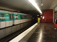
 Renovated MF 77 rolling stock on Aubervilliers–Pantin–Quatre Chemins in 2022 | |||||||||||
| General information | |||||||||||
| Location | Aubervilliers Île-de-France France | ||||||||||
| Coordinates | 48°54′14″N 2°23′33″E | ||||||||||
| Owned by | RATP | ||||||||||
| Operated by | RATP | ||||||||||
| Line(s) | |||||||||||
| Platforms | 2 (2 side platforms) | ||||||||||
| Tracks | 2 | ||||||||||
| Other information | |||||||||||
| Station code | 03-05 | ||||||||||
| Fare zone | 2 | ||||||||||
| History | |||||||||||
| Opened | 4 October 1979 | ||||||||||
| Passengers | |||||||||||
| 4,131,018 (2020) | |||||||||||
| Services | |||||||||||
| |||||||||||
| Location | |||||||||||
 Aubervilliers–Pantin–Quatre Chemins Location within Paris | |||||||||||
History
Aubervilliers–Pantin–Quatre Chemins opened on 4 October 1979 as part of an extension from Porte de la Villette to Fort d'Aubervilliers.
In 2019, the station was used by 7,215,915 passengers, making it the 37th busiest of the Métro network, out of 302 stations.[1]
In 2020, the station was used by 4,131,018 passengers amidst the COVID-19 pandemic, making it the 27th busiest of the Métro network, out of 305 stations.[2]
Passenger services
Access
The station has 5 entrances along avenue de la République and avenue Jean-Jaurès.
Station layout
| Street Level | ||
| B1 | Mezzanine | |
| Line 7 platforms | Side platform, doors will open on the right | |
| Southbound | ← | |
| Northbound | | |
| Side platform, doors will open on the right | ||
Platforms
The station has a standard configuration with 2 tracks surrounded by 2 side platforms.
Other connections
The station is also served by lines 150, 152, 170, and 249 of the RATP bus network, and at night, by line N42 of the Noctilien bus network.
Nearby
- Église Sainte-Marthe des Quatre-Chemins
Gallery
 MF 77 at Aubervilliers–Pantin–Quatre Chemins
 One of the entrances of the station


References
- "Trafic annuel entrant par station du réseau ferré 2019". dataratp2.opendatasoft.com (in French). Retrieved 2022-01-31.
- "Trafic annuel entrant par station du réseau ferré 2020". data.ratp.fr (in French). Retrieved 2022-01-31.
- Roland, Gérard (2003). Stations de métro. D’Abbesses à Wagram. Éditions Bonneton.
На других языках
[de] Aubervilliers – Pantin – Quatre Chemins (Métro Paris)
Aubervilliers – Pantin – Quatre Chemins ist eine unterirdische Station der Pariser Métro. Sie befindet sich unterhalb der Avenue Jean Jaurès an der Grenze der Pariser Vororte Aubervilliers und Pantin und wird von der Métrolinie 7 bedient. Die Station ist nach den beiden Orten benannt.- [en] Aubervilliers–Pantin–Quatre Chemins (Paris Métro)
[ru] Обервилье — Пантен — Катр-Шемен (станция метро)
Обервилье — Пантен — Катр-Шемен (фр. Aubervilliers - Pantin - Quatre Chemins) — станция линии 7 Парижского метрополитена, расположенная на границе коммун Обервилье и Пантен департамента Сен-Сен-Дени. От них же станция получила две части своего названия. Третью же часть своего названия станция получила кварталу Катр-Шемен, названному в память о дороге, ведшей во Фландрию (ныне трасса N2).Другой контент может иметь иную лицензию. Перед использованием материалов сайта WikiSort.org внимательно изучите правила лицензирования конкретных элементов наполнения сайта.
WikiSort.org - проект по пересортировке и дополнению контента Википедии