railroad.wikisort.org - Station
Canning Town (en anglais : Canning Town Underground Station), est une station de la Jubilee line, du métro de Londres, en zone 2 et 3. Elle est située sur la Silvertown Way, à Canning Town sur le territoire du Borough londonien de Newham.
Cet article est une ébauche concernant le métro et Londres.
Vous pouvez partager vos connaissances en l’améliorant (comment ?) selon les recommandations des projets correspondants.
Ne doit pas être confondu avec Canning Town (DLR).
| Canning Town | ||||||||
 Entrée de la station. | ||||||||
| Localisation | ||||||||
|---|---|---|---|---|---|---|---|---|
| Pays | Royaume-Uni | |||||||
| Ville | Londres | |||||||
| Borough de Londres | Newham | |||||||
| Quartier | Canning Town | |||||||
| Adresse | Silvertown Way Canning Town London E16 1DQ |
|||||||
| Coordonnées géographiques | 51° 30′ 50″ nord, 0° 00′ 30″ est | |||||||
| Géolocalisation sur la carte : Grand Londres
| ||||||||
| Caractéristiques | ||||||||
| Position par rapport au sol |
Surface | |||||||
| Voies | 4 | |||||||
| Quais | 4 | |||||||
| Accessibilité | Oui | |||||||
| Zone | 2 et 3 | |||||||
| Transit annuel | 7,725 millions (2005) 8,099 millions (2007) |
|||||||
| Historique | ||||||||
| Mise en service | ||||||||
| Nom inaugural | Barkng Road | |||||||
| Gestion et exploitation | ||||||||
| Propriétaire | Métro de Londres | |||||||
| Exploitant | Transport for London | |||||||
| Ligne(s) | ||||||||
| Correspondances | ||||||||
| Métro DLR | Canning Town (DLR) | |||||||
| ||||||||
| modifier |
||||||||

Elle est en correspondance avec la station de Canning Town (DLR) du métro léger Docklands Light Railway.
Situation sur le réseau

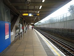
Située en surface, la station Canning Town de la Jubilee line du métro de Londres, dispose d'une plateforme de passage établie entre la station West Ham, en direction de la station terminus Stratford, et la station North Greenwich, en direction du terminus Stanmore (métro de Londres)[1]. Elle est en zone 2 et 3 Travelcard[2].
La plateforme dispose d'un quai central, numéroté 5 et 6, encadrant les deux voies de la ligne[1].
Histoire
Services aux voyageurs
Accès et accueil
Desserte
- Installations et desserte


Intermodalité
Projets
À proximité
- Canning Town
Notes et références
- (en) Franklin Jarrier, « Greater London : Transport Tracks Map (Tracks map with platforms, connexions & depots) Undeground, Overground, DLR, Tramlink & National Rail », sur carto.metro, (consulté le ).
- (en) « Canning Town Underground Station », sur Transport for London (consulté le )
Voir aussi
Articles connexes
- Métro de Londres (London Underground)
- Transport for London
- Liste des stations du métro de Londres
- Liste des stations fermées du métro de Londres
- Jubilee line
- Canning Town (DLR)
Liens externes
- (en) « Canning Town Underground Station », sur Transport for London.
- (en) « Canning Town », sur Transport for London.
| Nord/Ouest | Sud/Est | |||
|---|---|---|---|---|
| West Ham vers Stratford |
North Greenwich vers Stanmore | |||
 Portail du métro
  Portail de Londres
На других языках
[de] Canning Town (London Underground)
Canning Town ist eine Station der London Underground und der Docklands Light Railway (DLR) im Stadtbezirk London Borough of Newham. Die Nahverkehrsdrehscheibe liegt in der Travelcard-Tarifzone 2/3 an der Kreuzung der Hauptstraßen Barking Road und Silvertown Way. Im Jahr 2014 nutzten 10,10 Millionen Fahrgäste diesen Verkehrsknotenpunkt[1], zu dem auch ein Busbahnhof gehört.[en] Canning Town station
Canning Town is a London Underground, Docklands Light Railway (DLR) and London Buses station in Canning Town in London, England. It is designed as an intermodal metro and bus station, fully opening in 1999 as part of the Jubilee Line Extension - replacing the original station site north of the A13.[13] On 11 November 2015, the Mayor of London announced that it would be rezoned to be on the boundary of Travelcard Zone 2 and Travelcard Zone 3.[14]- [fr] Canning Town (métro de Londres)
[ru] Кеннинг Таун (станция)
Кеннинг-таун — пересадочная станция нескольких видов транспорта в районе Кеннинг Таун в восточном Лондоне, Англия. Станция обслуживается Юбилейной линией Лондонского метрополитена, Доклендским лёгким метро и местными автобусами. Станция расположена в третьей тарифной зоне. С 1846 по 1873 годы станция носила название Баркинг-роуд.Другой контент может иметь иную лицензию. Перед использованием материалов сайта WikiSort.org внимательно изучите правила лицензирования конкретных элементов наполнения сайта.
WikiSort.org - проект по пересортировке и дополнению контента Википедии