railroad.wikisort.org - Station
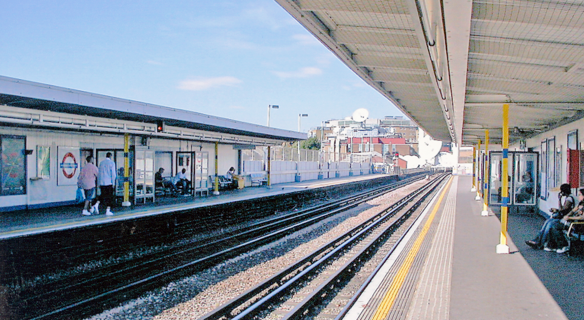
Shepherd's Bush Market is a London Underground station in the district of Shepherd's Bush in west London, England. It is on the Circle and Hammersmith & City Lines, between Goldhawk Road and Wood Lane stations, and it is in Travelcard Zone 2. Shepherd's Bush Market, from which the station takes its name, is an open-air market which runs parallel to the railway line.
| Shepherd's Bush Market | |
|---|---|
 | |
 Shepherd's Bush Market Location of Shepherd's Bush Market in Greater London | |
| Location | Shepherd's Bush |
| Local authority | London Borough of Hammersmith and Fulham |
| Managed by | London Underground |
| Station code | SBM[1] |
| Number of platforms | 2 |
| Fare zone | 2 |
| London Underground annual entry and exit | |
| 2017 | |
| 2018 | |
| 2019 | |
| 2020 | |
| 2021 | |
| Railway companies | |
| Original company | Hammersmith and City Railway |
| Pre-grouping | Hammersmith and City Railway |
| Post-grouping | Hammersmith and City Railway |
| Key dates | |
| 13 June 1864 | Station opened as Shepherds Bush |
| 1 April 1914 | Relocated and renamed Shepherd's Bush |
| 12 October 2008 | Renamed Shepherd's Bush Market |
| Other information | |
| External links | |
| WGS84 | 51.50583°N 0.22639°W |
History

Stations in Shepherd's Bush | ||||||||||||||||||||||||||||||||||||||||||||||||||||||||||||||||||||||||||||||||||||||
|---|---|---|---|---|---|---|---|---|---|---|---|---|---|---|---|---|---|---|---|---|---|---|---|---|---|---|---|---|---|---|---|---|---|---|---|---|---|---|---|---|---|---|---|---|---|---|---|---|---|---|---|---|---|---|---|---|---|---|---|---|---|---|---|---|---|---|---|---|---|---|---|---|---|---|---|---|---|---|---|---|---|---|---|---|---|---|
| ||||||||||||||||||||||||||||||||||||||||||||||||||||||||||||||||||||||||||||||||||||||
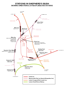
The Metropolitan Railway (MR) opened the original station on 13 June 1864 as Shepherd's Bush on its new extension to Hammersmith.[11] It was in the Shepherd's Bush Market area just south of Uxbridge Road. From 1 October 1877 until 31 December 1906 the MR also ran direct services along this line to Richmond via Hammersmith (Grove Road).[12]
The original Shepherd's Bush station closed in 1914 to be replaced by two new stations which opened on 1 April 1914: the new Shepherd's Bush station resited a short distance north across the Uxbridge Road, and Goldhawk Road about half a kilometre to the south.[12] Those stations remain in those locations but nothing exists of the former station buildings in the marketplace.
In 1900 the Central London Railway (CLR) opened its Shepherd's Bush station, now the Central line station, at the other end of Shepherd's Bush Green. For 108 years there were two Tube stations of the same name 0.3 miles (480 m) apart.
In 2008 the new London Overground Shepherd's Bush railway station was opened on the West London Line. To avoid the confusion of three stations named Shepherd's Bush, the Hammersmith & City line station was renamed Shepherd's Bush Market on 12 October 2008. The other two on the Central line and the West London line are close to each other and interchange is allowed, but not with Shepherd's Bush Market tube station.
Locale
The station is at the western end of Shepherd's Bush Green, and stands just across the road from the marketplace which gives it its name. Stallholders have traded on the strip of land beside the Hammersmith & City line since 1914, when the market took over the station's first site. The other end of the market is served by Goldhawk Road Underground station.[13]
Shepherd's Bush Market station is the nearest Underground stop to various entertainment venues including the Bush Theatre and the Shepherd's Bush Empire. It is also one of the Underground stations which serve Loftus Road Football Stadium, the home of Queens Park Rangers football club. Westfield and West12 shopping centres are near the station.
Connections
London Buses routes 207, 260, 283 and 607 and night route N207 serve the station.
See also
- Shepherd's Bush Market
- Shepherd's Bush stations
References
- "Station Codes" (PDF). Transport for London. Retrieved 25 April 2021.
- "Multi-year station entry-and-exit figures (2007–2017)". London Underground station passenger usage data. Transport for London. January 2018. Archived from the original (XLSX) on 31 July 2018. Retrieved 22 July 2018.
- "Station Usage Data" (CSV). Usage Statistics for London Stations, 2018. Transport for London. 21 August 2019. Archived from the original on 22 May 2020. Retrieved 27 April 2020.
- "Station Usage Data" (XLSX). Usage Statistics for London Stations, 2019. Transport for London. 23 September 2020. Archived from the original on 9 November 2020. Retrieved 9 November 2020.
- "Station Usage Data" (XLSX). Usage Statistics for London Stations, 2020. Transport for London. 16 April 2021. Retrieved 1 January 2022.
{{cite web}}: CS1 maint: url-status (link) - "Station Usage Data" (XLSX). Usage Statistics for London Stations, 2021. Transport for London. 12 July 2022. Retrieved 7 September 2022.
{{cite web}}: CS1 maint: url-status (link) - "Station Codes" (PDF). Transport for London. Retrieved 25 April 2021.
- "Station Codes" (PDF). Transport for London. Retrieved 25 April 2021.
- "Station Codes" (PDF). Transport for London. Retrieved 25 April 2021.
- "Station Codes" (PDF). Transport for London. Retrieved 25 April 2021.
- Sheppard, Francis Henry Wollaston (1971). London, 1808-1870: the infernal wen. University of California Press. p. 141. ISBN 978-0-520-01847-1.
- Rose, Douglas (1999). The London Underground: a Diagrammatic History (7th ed.). Capital Transport Publishing. ISBN 1-85414-219-4.
- Panton, Kenneth (2003). "Shepherd's Bush". London: a Historical Companion. Tempus Publishing. ISBN 0-7524-2577-3.
External links
- "Photographic Archive". London Transport Museum. Archived from the original on 18 March 2008.
- Shepherd's Bush station platform, 1934, note Metropolitan line style diamond "roundel".
- "Shepherd's Bush and White City development". Always Touch Out. Archived from the original on 13 July 2004.
| Preceding station | Following station | |||
|---|---|---|---|---|
| Goldhawk Road towards Hammersmith |
Circle line | Wood Lane towards Edgware Road via Aldgate | ||
| Hammersmith & City line | Wood Lane towards Barking | |||
| Former service | ||||
| Preceding station | Following station | |||
| Hammersmith Terminus |
Metropolitan line Hammersmith branch (1864-1908) |
Latimer Road towards Paddington | ||
| Metropolitan line Hammersmith branch (1908-1914) |
Wood Lane towards Paddington | |||
| Goldhawk Road towards Hammersmith |
Metropolitan line Hammersmith branch (1914-1914) |
|||
| Metropolitan line Hammersmith branch (1914-1920) |
Latimer Road towards Paddington | |||
| Metropolitan line Hammersmith branch (1920-1959) |
Wood Lane towards Paddington | |||
| Metropolitan line Hammersmith branch (1959-1990) |
Latimer Road towards Paddington | |||
Circle line | |||||||
|---|---|---|---|---|---|---|---|
| Stations |
| ||||||
| Rolling stock |
| ||||||
| History |
| ||||||
| See also |
| ||||||
| |||||||
Hammersmith & City line | |||||
|---|---|---|---|---|---|
| Stations |
| ||||
| Rolling stock |
| ||||
| History |
| ||||
| See also |
| ||||
| |||||
Metropolitan line | |||||||||||||||||
|---|---|---|---|---|---|---|---|---|---|---|---|---|---|---|---|---|---|
| Stations |
| ||||||||||||||||
| Rolling stock |
| ||||||||||||||||
| History |
| ||||||||||||||||
| Historic proposals |
| ||||||||||||||||
| |||||||||||||||||
На других языках
[de] Shepherd’s Bush Market (London Underground)
Shepherd’s Bush Market ist eine oberirdische Station der London Underground im Stadtbezirk London Borough of Hammersmith and Fulham. Sie liegt in der Travelcard-Tarifzone 2 an der Uxbridge Road im Stadtteil Shepherd’s Bush und wird von Zügen der Hammersmith & City Line und der Circle Line bedient. Im Jahr 2014 nutzten 3,66 Millionen Fahrgäste die Station[1] Nördlich der Station befindet sich das BBC Television Centre. In der Umgebung liegt Loftus Road, das Stadion der Queens Park Rangers.- [en] Shepherd's Bush Market tube station
[ru] Шепердс-Буш-Маркет (станция метро)
Шепердс-Буш-Маркет (англ. Shepherd's Bush Market) — станция лондонского метро линии Хаммерсмит-энд-Сити (англ. Hammersmith & City line), располагается в районе Шепердс-Буш в северной части округа Хаммерсмит-энд-Фулхэм. Относится ко второй тарифной зоне.Другой контент может иметь иную лицензию. Перед использованием материалов сайта WikiSort.org внимательно изучите правила лицензирования конкретных элементов наполнения сайта.
WikiSort.org - проект по пересортировке и дополнению контента Википедии